Enhanced Imagery
Enhanced Imagery streaming is in limited release and is not available to all accounts.
Enhanced Imagery layers bring the on-demand processing power of the Raster Analytics API to the diverse world of OGC clients. This means that any client that can display WMS images can view images processed with these proprietary technologies:
Raster Analytics
Raster Analytics is an API that emulates the Cloud Optimized GeoTIFF format. To clients, it looks like a library of TIFF images, but it is actually processing raw data on-the-fly as the image is read.
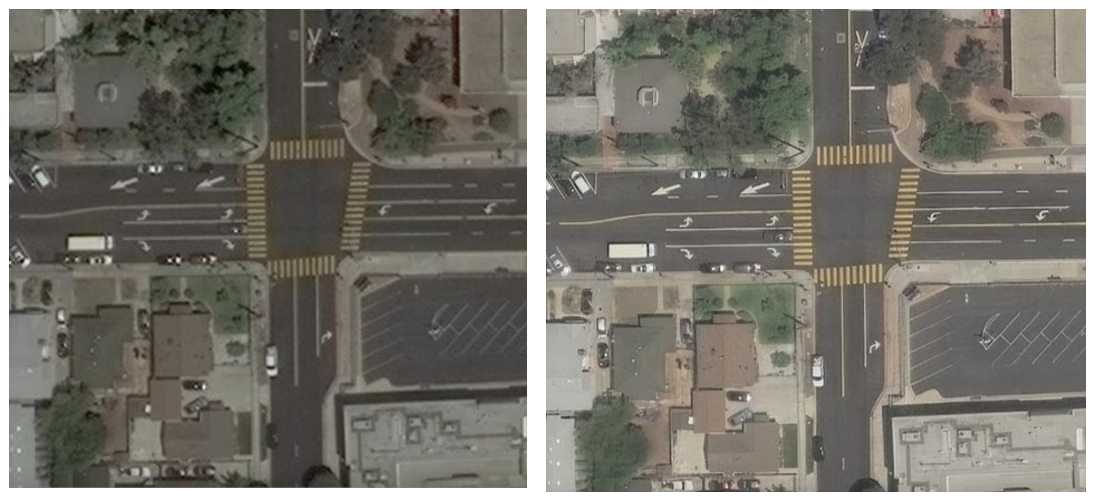
HD Imaging
High Definition (HD) imaging is a technology that improves the visual quality of the image, increasing sharpness and detail equivalent to images at half the captured resolution. In other words, imagery collected at 30 cm resolution looks equivalent to 15 cm imagery after HD is applied.
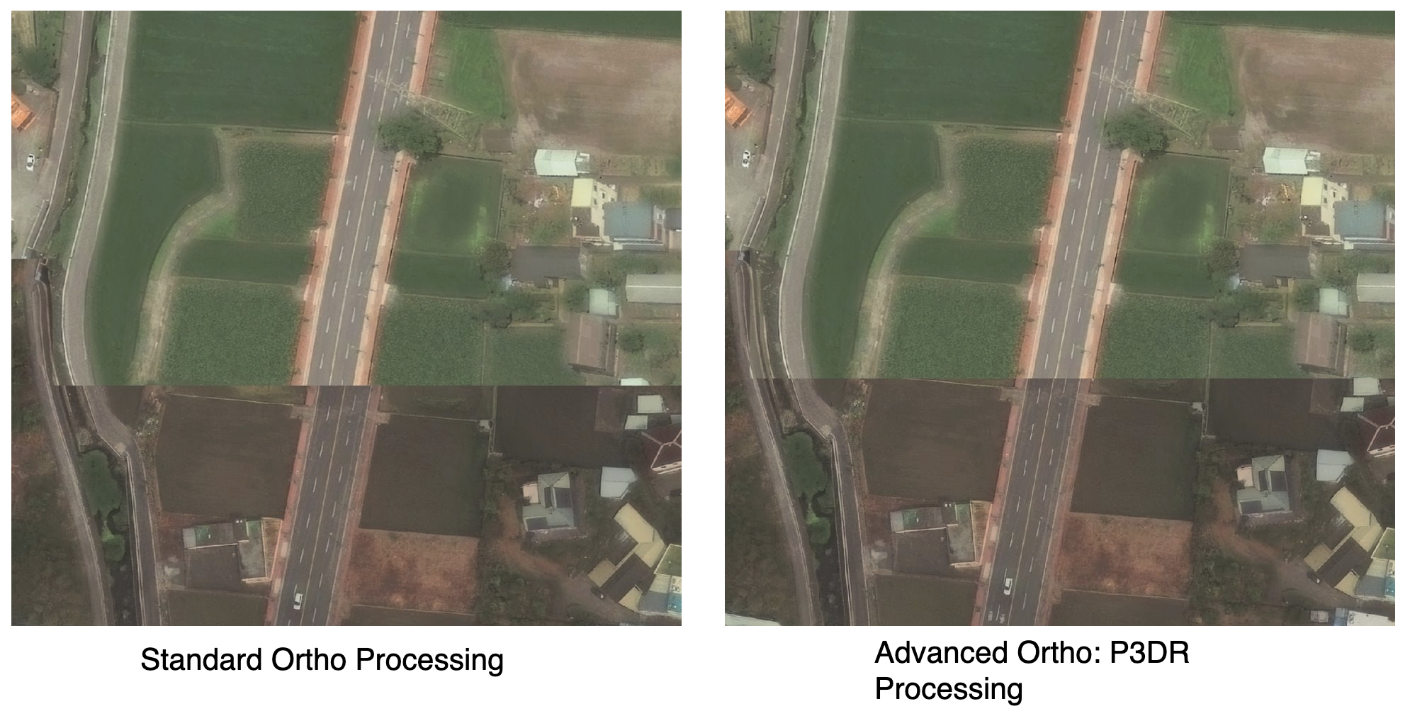
Precision3D™ Registration (P3DR®)
P3DR processing is available in select areas only.
P3DR creates more spatially accurate imagery by leveraging Maxar's high-resolution 3D terrain models. Using a high resolution elevation model reduces pixels shifts in areas with significant terrain relief. The 3D model is also used to further refine the orientation model of the image which improves the accuracy throughout the image. Combining these approaches provides improved mapping accuracies of 3m CE90 absolute and 1.5m CE90 coregistration accuracy.
Benefits
Many imagery users are interested in only specific areas within any given image. They may want detailed road markings, or an accurately positioned bridge. They do not need detailed waves on a water body or accurately positioned tree canopy.
Applying unwanted processing to a full image only makes the wanted parts more expensive. The only solution in the past was to provide a way for users to order areas of imagery with custom processing options, but this typically involved ordering workflows, minimum area requirements, and the waiting time for orders to be delivered.
Raster Analytics solves this by processing the imagery on demand. While many clients can now read the Cloud-optimized GeoTIFF format directly, it is not universally supported yet. It also does not offer the image stacking power of the Image Streaming WMS. Raster Analytics represents a single image at a time.
However, the new Enhanced Imagery streaming service is able to read from Raster Analytics just as it can read Daily Take images. This enables the on-demand images of Raster Analytics to seamlessly flow into WMS/WMTS layers.
Using the WMS/WMTS layers��
The Imagery Streaming servers will advertise these layers to customers with access to Enhanced Imagery:
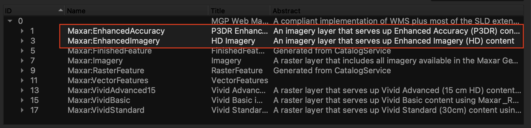
Maxar:EnhancedImagery
This layer uses HD processing to improve visual details.
HD is used only at zoom levels that use a pixel size smaller than the native resolution. This is typically at the WMTS zoom level 19 and above (approximately a 1:1000 map scale).
Maxar:EnhancedAccuracy
The Enhanced Accuracy Layer adds P3DR processing to increase the spatial accuracy of the returned imagery.
P3DR processing is used at all zoom levels and scales.
These layers can be used in place of Maxar:Imagery. Both layers use atmospheric compensation (AComp) to reduce this visual effects of haze and aerosol particles.
Finding enhanced images with WFS
Enhanced images are stored in the separate WFS feature type as other streaming images. You can use the WFS getfeature query against the typename of Maxar:EnhancedImageryFeature to search as covered in the WFS Guide - WFS Get Feature.
For maximum detail, you may want to add a filter to only show the higher resolution images:
groundSampleDistance < 0.35
To find images that can be streamed in Enhanced Accuracy with P3DR, use this CQL clause.
ancillaryType='p3dr'
An example WFS request to find Enhanced Imagery:
GET https://api.maxar.com/streaming/v1/ogc/wfs?service=WFS&request=getfeature&typenames=Maxar:EnhancedImageryFeature&cql_filter=groundSampleDistance < 0.35 and BBOX(featureGeometry, 5.98865807458, 47.3024876979, 15.0169958839, 54.983104153)&outputformat=json
Best practices for digitizing
Use WMTS
Since Enhanced Imagery tiles are generated on demand they take longer to return that reading data from a preprocessed image. Clients that use WMTS can request multiple small tiles at once which the server can process in parallel so WMTS will always perform faster than large WMS requests.
When WMTS tiles are requested the Enhanced Streaming server will also try to process adjacent tiles before they are needed and cache them. As you pan, the tiles can already be ready to load into view. However if you zoom out and then jump to a new location the server will have to start processing anew so tile response times will initially be slower as the server builds up a fresh cache of tiles.
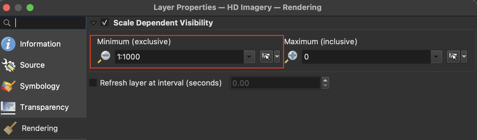
Use scale-dependent layer rules
Since the Enhanced layers are generated as needed, they will always be slower than loading Daily Take images or Vivid Mosaic® layers that have been preprocessed and are ready to stream. Therefore we recommend using the Enhanced layers only when needed for digitizing and switching to faster layers for navigation. An easy way to accomplish this is to set a scale-dependent rule on the layer so its only shown at scales where it can be used.
For HD imagery, this would mean setting the layer to be visible at a map scale of approximately 1:1000 or zoom level 19. Underneath you can use regular Maxar:Imagery layer to serve as a base layer. You can also try setting a scale-dependent rule on the base imagery so that it's only displayed when the Enhanced imagery isn't. This results in less tile loads which can reduce load time as well as consume less image credits. You can adjust the scale or zoom level if the transition is visually jarring.
Scale-dependent rules can also be useful for Enhanced Accuracy layers, but the scale or zoom level to toggle the layer visibility will vary depending on the size of the features being digitized. Try a zoom level of 17 or map scale of 1:4000 to start and adjust as needed.
Note Enhanced imagery is not available at zoom levels less than 13 (approximately 1:70,000)
Optional processing parameters
The published Enhanced WMS Layers all use AComp (atmospheric compensation) to improve image quality. It is possible to turn off AComp to get slightly faster response times. The URL query parameters hd, acomp, and p3dr, when passed to one of the Enhanced Accuracy layers, can turn that processing option on or off. The following settings are the default values:
| Parameter | Enhanced Imagery | Enhanced Accuracy |
|---|---|---|
acomp | true | true |
hd | true | false |
p3dr | false | true |
To use the Enhanced Accuracy with HD on and AComp off, you would include these parameters in your WMS request:
layer=Maxar:EnhancedAccuracy&acomp=false&hd=true
WMS examples
WMS request of Enhanced Accuracy with no filters or parameters
https://api.maxar.com/streaming/v1/ogc/wms?service=WMS&request=getmap&layers=Maxar:EnhancedAccuracy&width=512&height=512&format=image/vnd.jpeg-png&bbox=39.515,-105.0, 39.52,-104.995&crs=EPSG:4326&version=1.3.0
WMS request of Enhanced Imagery with a CQL filter to limit images to low cloud cover
https://api.maxar.com/streaming/v1/ogc/wms?service=WMS&request=getmap&layers=Maxar:EnhancedImagery&cql_filter=cloudCover<0.1&width=512&height=512&format=image/vnd.jpeg-png&bbox=39.52,-104.997, 39.522,-104.995&crs=EPSG:4326&version=1.3.0
WMS request of Enhanced Accuracy with AComp turned off via a parameter
https://api.maxar.com/streaming/v1/ogc/wms?service=WMS&request=getmap&layers=Maxar:EnhancedAccuracy&width=512&height=512&format=image/vnd.jpeg-png&bbox=39.515,-105.0, 39.52,-104.995&crs=EPSG:4326&version=1.3.0&acomp=false
WMTS example
WMTS request of Enhanced Accuracty with a CQL filter to limit display to WorldView 3 images with low cloud cover
https://api.maxar.com/streaming/v1/ogc/gwc/service/wmts?service=WMTS&request=GetTile&version=1.0.0&layer=Maxar:EnhancedAccuracy&format=image/png&tilematrixset=EPSG:3857&tilematrix=EPSG:3857:20&tilerow=449313&tilecol=877082&cql_filter=cloudCover<0.1 and source='WV03'