ArcMap Hub Add-in
Esri will be retiring the ArcMap application on March 1, 2026. At that time Vantor will also retire the ArcMap Vantor Hub Add-in. No further updates will be made to the Add-in. This documentation page and the download link will also be removed on that date.
Install the ArcMap Hub Add-in to bring georeferenced high-resolution satellite imagery, Vivid Basemaps, and Analytics into your GIS project using OGC-compliant web services.
- Latest version: 1.6.1
- Zip file name:
Vantor_Hub_ArcMap_v1.6.1.zip - ArcMap version requirements:ArcMap 10.7.1 or later
What's new in 1.6.1
- A bug with the Vivid Advanced layer is now fixed.
 GeoEye-1 image in ArcMap add-in
Download and Install the ArcMap Hub Add-in
- Click the link above to download the zip file to your local file location.
- Unzip the file.
- Open the ArcMap application.
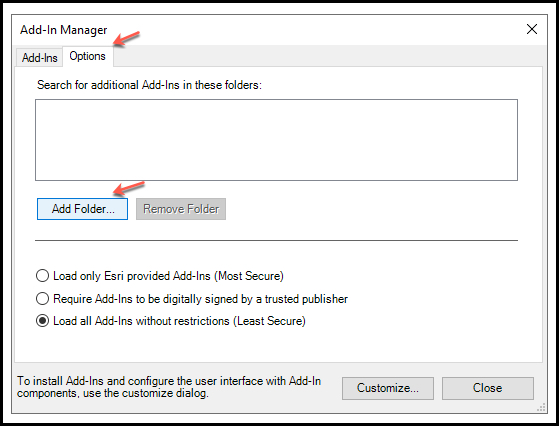
- From the top menu, choose the "Customize" tab, then select "Add-in Manager" from the menu.

- Select "options" from the top menu of the Add-in Manager, and then choose "Add Folder".
- Navigate to your download location and select the
Vantor_Hub_ArcMap_v1.6.1directory.
Once you see the file path in the box, select the "Close" button.
- Close ArcMap and re-open.
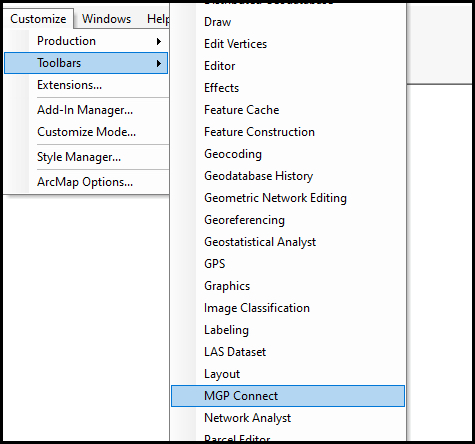
"MGP Connect" toolbar
When you re-open ArcMap for the first time, the "MGP Connect" toolbar will appear.

Click on the Maxar logo on the toolbar to open the login screen.
You can also access the Hub Add-in from the Toolbar menu.
The numbers on the following image correspond to the numbered descriptions below it.
![]()
- Login screen
- WMTS imagery and Vivid basemap layers
- Filters
- Change Monitoring (CM)
Once you are logged in, you can zoom in to any location on Earth to see imagery or Vivid basemaps. You can also apply filters to further refine imagery results.
Imagery
When logged in to "MGP Connect", the ArcMap Hub Add-in offers the following content and capabilities:
- View available imagery (image strips) when you are zoomed in to an extent below 1:50,000
- Filter for imagery based on metadata values
- Display metadata for a selected image within Table of Contents
Projections
If you are using an MXD map file, it may show multiple projections to choose from. The Hub Add-in defaults to "WGS 1984 web mercator (auxiliary sphere)" because this is the projection that works best with Hub services. Selecting any other projection will result in a drawing error.
Selecting imagery
To select imagery, choose "Maxar Imagery" from the layers in the left panel.
Example:
Note: Imagery will not display if you are zoomed out too far.
Filtering
Choose the "Filter" option from the "MGP Connect" toolbar to open the filter panel. Check the box next to the filter options you want to set and then set the filter values. Closing the filter form sets all your imagery filters back to the defaults. If you want the filters to persist, minimize the filter panel instead of closing it.
The following filters can be applied for image strips:
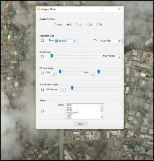
| Filter name | Description | Allowed values |
|---|---|---|
| Images to Show | Select the maximum number of images to show in the results by choosing the radio button next to the number. | None, 5, 10, 25, 50 |
| Acquisition Date | Use the calendar picker to filter for acquisitions (image strips) captured by the satellite between the specified start and end date, inclusive. | Start date and End date must be set to the current date or earlier. |
| Cloud Cover | Filter for imagery at or below the specified maximum cloud cover percentage. | 1 - 100% |
| Off Nadir Angle | Filter for imagery with an off nadir angle between the specified minimum and maximum values, inclusive. | Allowed values for both minimum and maximum are 0-60. |
| Sensors | Filter by selected sensor(s). Multiple sensors can be selected. | GE01, WV01, WV02, WV03_VNIR, WV04, LG01, LG02, LG03, LG04. |
| Sun Elevation Angle | Filter for imagery by Sun Elevation Angle. | 1-100 |
Vivid basemaps
To select a Vivid basemap layer, select if from the left panel and deselect "Maxar Imagery". Vivid basemaps are available (most recent production block pixels) for the following products:
| Vivid basemap product | Description |
|---|---|
| Vivid Advanced 15 cm HD | An imagery basemap with 15 cm HD Product GSD and 5m CE90 accuracy, plus committed image currency and advanced aesthetics, including minimal clouds and shear. Vivid Advanced 15 is produced annually with new imagery collections to maintain a current, clear view of the ground and is available for select cities. |
| Vivid Standard 30 cm HD | A global imagery basemap with 30 cm HD Product GSD and 5m CE90 accuracy, and includes the most recent imagery available that provides a high quality, clear view of the ground. Vivid Standard is produced annually to incorporate new imagery collections. |
Vivid basemaps can be viewed with or without seamlines.

Enabling seamlines
Check the Seamlines box, then left-click on any point in the viewport to invoke Pop-up information showing acquisition date, sensor, and more of that particular point.
Change Monitoring (CM)
To view CM data, choose the CM icon from the "MGP Connect" toolbar, then choose one or more CM layers from the menu.
Choose one or more CM layers from the menu.

To view metadata:
- select the ArcMap "Identify" tool from the top menu.
- click a cell to view the metadata.

Polygons are best viewed at zoom levels 1 - 100. Higher zoom levels will return heatmap tiles.
Known Issues
The CM layer "PCM EO and SAR 2023" currently has no data.