Intro to the Basemaps API
Overview
The Streaming - Basemap API supports OGC requests for Vivid Mosaic basemaps and seamlines. This API uses the Open Geospatial Consortium (OGC) API services Web Feature Service (WFS), Web Map Service (WMS) and Web Map Tile Service (WMTS) to provide Maxar's Vivid Mosaic basemaps and seamlines and their metadata.
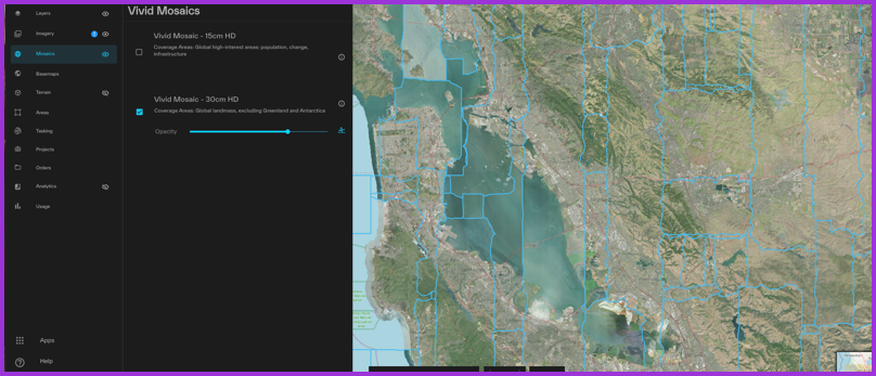 A Vivid Mosaic 30-centimeter imagery basemap with seamlines overlaid in the Vantor Hub User Interface
Vivid Mosaic basemaps
Vivid Mosaic basemaps provide high-quality, visually consistent views of Earth. These basemaps are ideal for use as map contextual layers, for extracting map features at scale, and for visualization within an application. The following Vivid Mosaic basemaps are available to stream via OGC-compliant services:
| Vivid Mosaic Basemap | Description |
|---|---|
| Vivid Mosaic 15 cm | An imagery basemap with 15cm HD Product GSD and 5m CE90 accuracy, plus committed image currency and advanced aesthetics, including minimal clouds and shear. |
| Vivid Mosaic 30 cm | A global imagery basemap with 30 cm HD Product GSD and 5m CE90 accuracy, and includes the most recent imagery available that provides a high quality, clear view of the ground. |
Vivid Mosaic Basemaps are available to stream via the following OGC-compliant streaming services.
| Service | Description | URL Path | Documentation |
|---|---|---|---|
| Web Feature Service (WFS) | Provides the vector geometry and attributes of a feature in Geographic Markup Language (GML) format. | /basemaps/v1/ogc/wfs | WFS Guide |
| Web Map Service (WMS) | Returns a map image in a standard image format. Images can be filtered by feature metadata. | /basemaps/v1/ogc/wms | WMS Guide |
| Web Map Tile Service (WMTS) | Returns pre-generated images as map tiles. This service is optimized for faster server response times. | /basemaps/v1/ogc/gwc/service/wmts | WMTS Guide |
Vivid Mosaic seamlines
Seamlines show the boundaries of each segment of the imagery mosaic that make up the basemap. Use WFS to get the metadata for seamlines. WMS and WMTS return seamlines in raster format. Seamlines are available for each of the Vivid Mosaic products listed above.
Vivid Seamlines are available to stream via the following OGC-compliant streaming services:
| Service | Description | URL Path | Documentation |
|---|---|---|---|
| Web Feature Service (WFS) | Provides the vector geometry and attributes of a feature in Geographic Markup Language (GML) format. | /basemaps/v1/seamlines/wfs | WFS Guide |
| Web Map Service (WMS) | Returns a map image in a standard image format. Images can be filtered by feature metadata. | /basemaps/v1/seamlines/ows?SERVICE=WMS | WMS Guide |
| Web Map Tile Service (WMTS) | Returns pre-generated images as map tiles. This service is optimized for faster server response times. | /basemaps/v1/seamlines/gwc/service/wmts | WMTS Guide |
Integration Examples
Leaflet Map
To use the Maxar:seamline layer in a Leaflet map, follow the Tutorial: Creating a Leaflet Map with WMS for instructions.
QGIS
To use WMTS or WMS in QGIS, See Tutorial: QGIS Integration.
Additional Services
Users who want to display map-like imagery base layer in an interface will want the Streaming - Imagery API instead. To obtain imagery not formatted for screen display, consider ordering images as files through the Ordering API or reading image data directly from the Raster Analytics service.